
Mapa topográfico Hirschwang
Mapa interativo
Clique no mapa para exibir a altitude.
Sobre este mapa
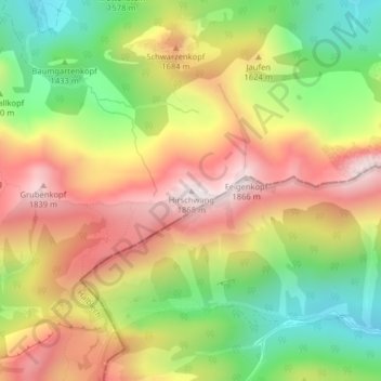
Nome: Mapa topográfico Hirschwang, altitude, relevo.
Local: Hirschwang, Halblech, Landkreis Ostallgäu, Bayern, Deutschland (47.57871 10.88448 47.57881 10.88458)
Altitude média: 1481 m
Altitude mínima: 1102 m
Altitude máxima: 1857 m
Outros mapas topográficos
Clique em um mapa para visualizar sua topografia, sua altitude e seu relevo.
Hochplatte
Deutschland > Bayern > Landkreis Ostallgäu > Halblech
Hochplatte, Halblech, Landkreis Ostallgäu, Bayern, Deutschland
Altitude média: 1646 m
Ostern
Deutschland > Bayern > Landkreis Ostallgäu > Halblech
Ostern, Halblech, Landkreis Ostallgäu, Bayern, 87642, Deutschland
Altitude média: 798 m