
Mapa topográfico Dhanbad
Mapa interativo
Clique no mapa para exibir a altitude.
Sobre este mapa
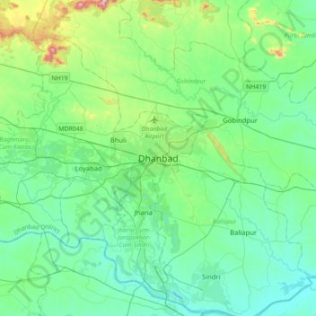
Nome: Mapa topográfico Dhanbad, altitude, relevo.
Altitude média: 212 m
Altitude mínima: 113 m
Altitude máxima: 633 m
Dhanbad has an average elevation of 227 m (745 ft). Its geographical length (extending from north to south) is 15 miles (24 km) and the breadth (stretching across east to West) is 10 miles (16 km). It shares its boundaries with West Bengal in the eastern and southern part, Giridih and Dumka in the North and Bokaro District in the west. Dhanbad comes under the Chota Nagpur Plateau.
Outros mapas topográficos
Clique em um mapa para visualizar sua topografia, sua altitude e seu relevo.
Bhuli
India > Jharkhand > Dhanbad-Cum-Kenduadih-Cum-Jagata
Bhuli, Dhanbad-Cum-Kenduadih-Cum-Jagata, Dhanbad District, Jharkhand, 828130, India
Altitude média: 236 m