
Mapa topográfico Trient
Mapa interativo
Clique no mapa para exibir a altitude.
Sobre este mapa
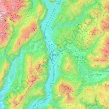
Nome: Mapa topográfico Trient, altitude, relevo.
Altitude média: 970 m
Altitude mínima: 93 m
Altitude máxima: 3117 m
Die Stadt liegt, umgeben von Bergen, im Etschtal direkt an der Etsch, 55 km südlich von Bozen und 100 km nördlich von Verona. Ihr Zentrum befindet sich auf einer Höhe von 194 m ü. NHN. Das Gemeindegebiet erstreckt sich über eine Fläche von 158 km².
Outros mapas topográficos
Clique em um mapa para visualizar sua topografia, sua altitude e seu relevo.
Vason
Italien > Trentino-Südtirol > Autonome Provinz Trient > Trient
Vason, Trient, Territorio Val d'Adige, Autonome Provinz Trient, Trentino-Südtirol, Italien
Altitude média: 1344 m
Vaneze
Italien > Trentino-Südtirol > Autonome Provinz Trient > Trient
Vaneze, Trient, Territorio Val d'Adige, Autonome Provinz Trient, Trentino-Südtirol, Italien
Altitude média: 1014 m
Candriai
Italien > Trentino-Südtirol > Autonome Provinz Trient > Trient > Sardagna
Candriai, Sardagna, Trient, Territorio Val d'Adige, Autonome Provinz Trient, Trentino-Südtirol, 38122, Italien
Altitude média: 744 m
Sopramonte
Italien > Trentino-Südtirol > Autonome Provinz Trient > Trient
Sopramonte, Trient, Territorio Val d'Adige, Autonome Provinz Trient, Trentino-Südtirol, Italien
Altitude média: 718 m