
Mapa topográfico Mühleip
Mapa interativo
Clique no mapa para exibir a altitude.
Sobre este mapa
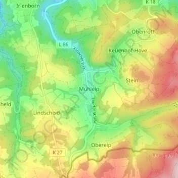
Nome: Mapa topográfico Mühleip, altitude, relevo.
Altitude média: 225 m
Altitude mínima: 117 m
Altitude máxima: 359 m
Outros mapas topográficos
Clique em um mapa para visualizar sua topografia, sua altitude e seu relevo.
Rankenhohn
Deutschland > Nordrhein-Westfalen > Rhein-Sieg-Kreis > Eitorf
Rankenhohn, Eitorf, Rhein-Sieg-Kreis, Nordrhein-Westfalen, 53809, Deutschland
Altitude média: 227 m
Siebigteroth
Deutschland > Nordrhein-Westfalen > Rhein-Sieg-Kreis > Eitorf > Lascheid
Siebigteroth, Lascheid, Eitorf, Rhein-Sieg-Kreis, Nordrhein-Westfalen, 53783, Deutschland
Altitude média: 173 m
Hüppelröttchen
Deutschland > Nordrhein-Westfalen > Rhein-Sieg-Kreis > Eitorf
Hüppelröttchen, Linkenbach, Eitorf, Rhein-Sieg-Kreis, Nordrhein-Westfalen, 53783, Deutschland
Altitude média: 284 m