
Mapa topográfico Acadia National Park
Mapa interativo
Clique no mapa para exibir a altitude.
Sobre este mapa
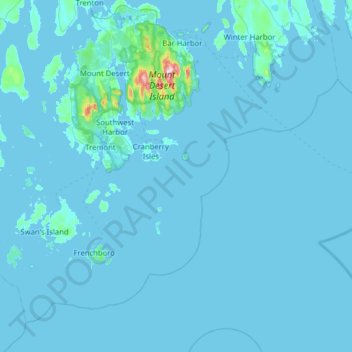
Nome: Mapa topográfico Acadia National Park, altitude, relevo.
Altitude média: 9 m
Altitude mínima: -3 m
Altitude máxima: 452 m
The ecological zones at Acadia National Park, from highest to lowest elevation, include: nearly barren mountain summits; northern boreal and eastern deciduous forests on the mountainsides; freshwater lakes and ponds, as well as wetlands like marshes and swamps in the valleys between mountains; and the Atlantic shoreline with rocky and sandy beaches, intertidal and subtidal zones.
Outros mapas topográficos
Clique em um mapa para visualizar sua topografia, sua altitude e seu relevo.
Fresh Meadow
United States > Maine > Hancock County > Bar Harbor
Fresh Meadow, Bar Harbor, Hancock County, Maine, United States
Altitude média: 17 m
Cadillac Mountain
United States > Maine > Hancock County > Bar Harbor
Cadillac Mountain, Bar Harbor, Hancock County, Maine, 04609, United States
Altitude média: 233 m
Salsbury Cove
United States > Maine > Hancock County > Bar Harbor
Salsbury Cove, Bar Harbor, Hancock County, Maine, United States
Altitude média: 15 m