
Mapa topográfico Andermatt
Mapa interativo
Clique no mapa para exibir a altitude.
Andermatt
Andermatt (Romansh: Ursera (help·info)) is a mountain village and municipality in the canton of Uri in Switzerland. At an elevation of 1,437 meters (4,715 ft) above sea level, Andermatt is located at the center of the Saint-Gotthard Massif and the historical center cross of north-south and east-west traverses of Switzerland. It is some 28 km (17 mi) south of Altdorf, the capital of Uri.
Sobre este mapa
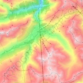
Nome: Mapa topográfico Andermatt, altitude, relevo.
Local: Andermatt, Korporation Ursern, Uri, 6490, Switzerland (46.56410 8.54654 46.67706 8.68192)
Altitude média: 2127 m
Altitude mínima: 1023 m
Altitude máxima: 2972 m
Outros mapas topográficos
Clique em um mapa para visualizar sua topografia, sua altitude e seu relevo.