
Mapa topográfico Norwalk
Mapa interativo
Clique no mapa para exibir a altitude.
Sobre este mapa
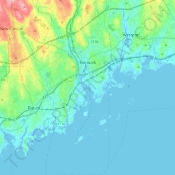
Nome: Mapa topográfico Norwalk, altitude, relevo.
Local: Norwalk, Fairfield County, Connecticut, United States (41.02045 -73.47457 41.17127 -73.38029)
Altitude média: 24 m
Altitude mínima: -7 m
Altitude máxima: 145 m
Norwalk's topography is dominated by its coastline along Long Island Sound, the Norwalk River and its eastern and western banks, and the Norwalk Islands. The highest elevation is 315 feet (96 m) above sea level on the fairway of the 16th hole of the Silvermine Golf Course, and the low elevation is sea level on Long Island Sound.