
Mapa topográfico Ogden
Mapa interativo
Clique no mapa para exibir a altitude.
Ogden
According to the United States Census Bureau, the city has an area of 26.6 square miles (69.0 km2), all land. Elevations in the city range from about 4,300 to 5,000 feet (1,300 to 1,500 m) above sea level.
Sobre este mapa
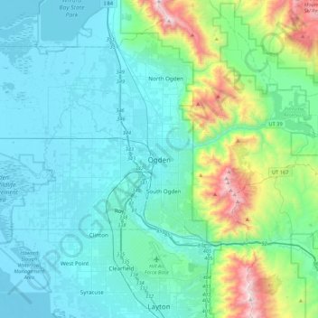
Nome: Mapa topográfico Ogden, altitude, relevo.
Local: Ogden, Weber County, Utah, 84403, United States (41.06300 -112.13384 41.38300 -111.81384)
Altitude média: 1557 m
Altitude mínima: 1279 m
Altitude máxima: 2946 m