
Faça uma doação
Prepare-se para a sua próxima aventura:
Como Associado da Amazon, este site recebe uma comissão sobre compras elegíveis sem custo adicional para si.
Mapa topográfico Orinda
Clique no mapa para exibir a altitude.
Faça uma doação
Prepare-se para a sua próxima aventura:
Como Associado da Amazon, este site recebe uma comissão sobre compras elegíveis sem custo adicional para si.
Orinda
The area is characterized by a warm-summer Mediterranean climate (Köppen climate classification Csb) with cool, rainy winters and warm, dry summers. Because Orinda is located in a hilly area, microclimates often dominate temperature differences in short distances. The Oakland Hills often block the cool foggy conditions that can be seen in Oakland and the innerbay. In the summer, fog can spill over the Oakland hills, cooling off the area. Heatwaves from the inland areas can be felt much more in Orinda than in Oakland and the innerbay during the summer. In the winter, Orinda often sees more precipitation than surrounding areas because of its higher elevation. Snowfall is rare but not unheard of. A dusting of snow may occur in any given year because of the elevation. During stable conditions in the winter, mornings can be cold and frosty in downtown and lower-lying areas, while the higher hills surrounding the area may be several degrees warmer.
Faça uma doação
Prepare-se para a sua próxima aventura:
Como Associado da Amazon, este site recebe uma comissão sobre compras elegíveis sem custo adicional para si.
Sobre este mapa
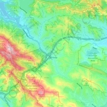
Nome: Mapa topográfico Orinda, altitude, relevo.
Altitude média: 246 m
Altitude mínima: 88 m
Altitude máxima: 570 m
Faça uma doação
Prepare-se para a sua próxima aventura:
Como Associado da Amazon, este site recebe uma comissão sobre compras elegíveis sem custo adicional para si.