
Faça uma doação
Prepare-se para a sua próxima aventura:
Como Associado da Amazon, este site recebe uma comissão sobre compras elegíveis sem custo adicional para si.
Mapa topográfico Sun Valley
Clique no mapa para exibir a altitude.
Faça uma doação
Prepare-se para a sua próxima aventura:
Como Associado da Amazon, este site recebe uma comissão sobre compras elegíveis sem custo adicional para si.
Sun Valley
Sun Valley is a resort city in Blaine County, Idaho, United States. The resort is adjacent to the city of Ketchum and within the greater Wood River valley. The population was 1,406 at the 2010 census, down from 1,427 in 2000. The elevation of Sun Valley (at the Lodge) is 5,920 feet (1,805 m) above sea level. Scheduled passenger airline service is available via the Friedman Memorial Airport located in nearby Hailey, approximately 15 miles (25 km) south. Visitors to Sun Valley are relatively close to the Sawtooth National Recreation Area, accessed over Galena Summit on State Highway 75, the Sawtooth Scenic Byway.
Faça uma doação
Prepare-se para a sua próxima aventura:
Como Associado da Amazon, este site recebe uma comissão sobre compras elegíveis sem custo adicional para si.
Sobre este mapa
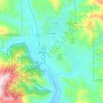
Nome: Mapa topográfico Sun Valley, altitude, relevo.
Local: Sun Valley, Blaine County, Idaho, United States (43.63996 -114.36125 43.72314 -114.30661)
Altitude média: 1988 m
Altitude mínima: 1724 m
Altitude máxima: 2780 m
Faça uma doação
Prepare-se para a sua próxima aventura:
Como Associado da Amazon, este site recebe uma comissão sobre compras elegíveis sem custo adicional para si.