
Mapa topográfico Toquepala Caves
Mapa interativo
Clique no mapa para exibir a altitude.
Sobre este mapa
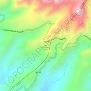
Nome: Mapa topográfico Toquepala Caves, altitude, relevo.
Altitude média: 2258 m
Altitude mínima: 2061 m
Altitude máxima: 2541 m
Situated in the western Andes, they are in the Moquegua Region of the Osmore River. Located at an elevation of 2,200 m (7,200 ft) (2,800 m (9,200 ft) is also mentioned in another source[1]), they are two small caves each 15 m × 5 m (49 ft × 16 ft) in size, with a depth of 5 m (16 ft). The two Toquepala Caves in the high Sierra are located near the Quebrada Cimarron or along the Rio Locumba, which is a dry stream flowing from the Sierra to the desert.[2] The best known of the caves is "Abrigo del Diablo".[3]