
Mapa topográfico Harlowton
Mapa interativo
Clique no mapa para exibir a altitude.
Sobre este mapa
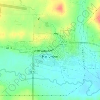
Nome: Mapa topográfico Harlowton, altitude, relevo.
Local: Harlowton, Wheatland County, Montana, United States (46.43090 -109.85193 46.44233 -109.82353)
Altitude média: 1286 m
Altitude mínima: 1264 m
Altitude máxima: 1327 m
The Upper Musselshell River Valley is named for the Musselshell River, which got its name from the large number of freshwater mussels found in its river bed. In the fall and winter weather, the bison would migrate to the lower altitudes along the Musselshell River. Early plains hunters, taking advantage of the large bison population, frequented this area. Some of the tribes that traveled through the area were the Crow, Blackfeet, Flathead, Gros Ventre, Northern Cheyenne, Nez Perce, Shoshones, Sioux, and Assiniboine.
Outros mapas topográficos
Clique em um mapa para visualizar sua topografia, sua altitude e seu relevo.
Judith Gap
United States > Montana > Wheatland County
Judith Gap, Wheatland County, Montana, 59453, United States
Altitude média: 1406 m