
Faça uma doação
Prepare-se para a sua próxima aventura:
Como Associado da Amazon, este site recebe uma comissão sobre compras elegíveis sem custo adicional para si.
Mapa topográfico Beaver Creek
Clique no mapa para exibir a altitude.
Faça uma doação
Prepare-se para a sua próxima aventura:
Como Associado da Amazon, este site recebe uma comissão sobre compras elegíveis sem custo adicional para si.
Beaver Creek
Like most of Yukon, Beaver Creek has a subarctic climate (Dfc), and NRC Plant Hardiness Zone of 0a. It is situated at an elevation of approximately 650 m (2,130 ft). Beaver Creek experiences annual temperature average daily highs of 20 °C (68 °F) in July and average daily lows of −30 °C (−22 °F) in January. Record high temperature was 32.8 °C (91.0 °F) on June 15, 1969, and the lowest was −55.0 °C (−67.0 °F) on January 17, 1971. Beaver Creek has an average annual snowfall of 117.9 cm (46.42 in) and 298.6 mm (11.76 in) of rainfall.
Faça uma doação
Prepare-se para a sua próxima aventura:
Como Associado da Amazon, este site recebe uma comissão sobre compras elegíveis sem custo adicional para si.
Sobre este mapa
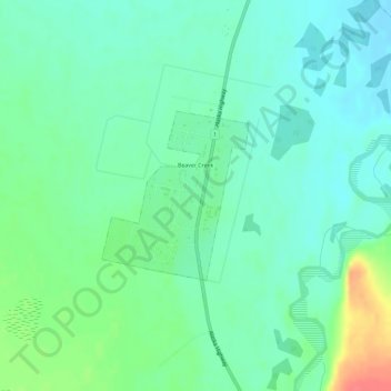
Nome: Mapa topográfico Beaver Creek, altitude, relevo.
Local: Beaver Creek, Yukon, Canada (62.37597 -140.89129 62.38767 -140.86934)
Altitude média: 662 m
Altitude mínima: 646 m
Altitude máxima: 703 m
Faça uma doação
Prepare-se para a sua próxima aventura:
Como Associado da Amazon, este site recebe uma comissão sobre compras elegíveis sem custo adicional para si.