
Mapa topográfico Vadakkanad
Mapa interativo
Clique no mapa para exibir a altitude.
Sobre este mapa
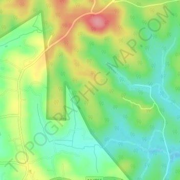
Nome: Mapa topográfico Vadakkanad, altitude, relevo.
Local: Vadakkanad, Sulthanbathery, Wayanad District, Kerala, India (11.67483 76.28606 11.70790 76.31413)
Altitude média: 896 m
Altitude mínima: 855 m
Altitude máxima: 958 m
Outros mapas topográficos
Clique em um mapa para visualizar sua topografia, sua altitude e seu relevo.
Edakkal
India > Kerala > Sulthanbathery > Ambalavayal
Edakkal, Ambalavayal, Sulthanbathery, Wayanad District, Kerala, India
Altitude média: 927 m
Nellarachal
India > Kerala > Sulthanbathery
Nellarachal, Sulthanbathery, Wayanad District, Kerala, India
Altitude média: 781 m
Kuruva Island
India > Kerala > Sulthanbathery
Kuruva Island, Sulthanbathery, Wayanad District, Kerala, India
Altitude média: 733 m
Kenichira
India > Kerala > Sulthanbathery
Kenichira, Sulthanbathery, Wayanad District, Kerala, 673596, India
Altitude média: 770 m
Kenichira
India > Kerala > Sulthanbathery
Kenichira, Sulthanbathery, Wayanad District, Kerala, 673596, India, Poothadi
Altitude média: 788 m
Marakavu
India > Kerala > Sulthanbathery > Pulpally
Marakavu, Pulpally, Sulthanbathery, Wayanad, Kerala, India
Altitude média: 769 m
Sulthan Bathery
India > Kerala > Sulthanbathery > Sultan Bathery
Sulthan Bathery, Sultan Bathery, Sulthanbathery, Wayanad, Kerala, 673592, India
Altitude média: 873 m
Sultan Bathery
India > Kerala > Sulthanbathery
Sultan Bathery, Sulthanbathery, Wayanad, Kerala, 673592, India
Altitude média: 876 m
Koliyadi
India > Kerala > Sulthanbathery
Koliyadi, Sulthanbathery, Wayanad, Kerala, 673595, India
Altitude média: 886 m
Muthanga
India > Kerala > Sulthanbathery
Muthanga, Sulthanbathery, Wayanad District, Kerala, India
Altitude média: 866 m
Meenangadi
India > Kerala > Sulthanbathery > Meenangadi
Meenangadi, Sulthanbathery, Wayanad District, Kerala, 673591, India
Altitude média: 785 m