
Mapa topográfico Ehlingen
Mapa interativo
Clique no mapa para exibir a altitude.
Sobre este mapa
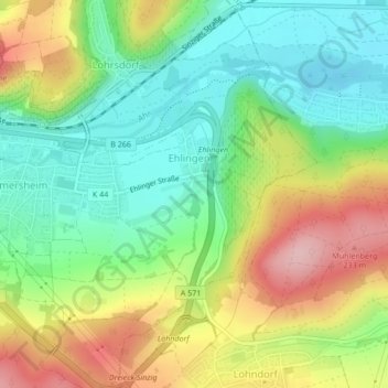
Nome: Mapa topográfico Ehlingen, altitude, relevo.
Altitude média: 136 m
Altitude mínima: 63 m
Altitude máxima: 246 m
Outros mapas topográficos
Clique em um mapa para visualizar sua topografia, sua altitude e seu relevo.
Neuenahr
Duitsland > Rijnland-Palts > Landkreis Ahrweiler > Bad Neuenahr-Ahrweiler
Neuenahr, Bad Neuenahr-Ahrweiler, Landkreis Ahrweiler, Rijnland-Palts, Duitsland
Altitude média: 242 m