
Mapa topográfico Emmaberg
Mapa interativo
Clique no mapa para exibir a altitude.
Sobre este mapa
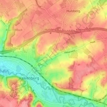
Nome: Mapa topográfico Emmaberg, altitude, relevo.
Altitude média: 116 m
Altitude mínima: 62 m
Altitude máxima: 151 m
Outros mapas topográficos
Clique em um mapa para visualizar sua topografia, sua altitude e seu relevo.
Valkenburg
Nederland > Limburg > Valkenburg
Valkenburg, Limburg, Nederland, 6301, Nederland
Altitude média: 121 m
Geuldal
Nederland > Limburg > Valkenburg > Houthem
Geuldal, Houthem, Valkenburg, Valkenburg aan de Geul, Limburg, Nederland
Altitude média: 116 m
Sibbe
Nederland > Limburg > Valkenburg
Sibbe, Valkenburg, Valkenburg aan de Geul, Limburg, Nederland, 6301 AR, Nederland
Altitude média: 138 m
Schaelsberg
Nederland > Limburg > Valkenburg
Schaelsberg, Euverem, Valkenburg, Valkenburg aan de Geul, Limburg, Nederland, 6301 PW, Nederland
Altitude média: 105 m
Cauberg
Nederland > Limburg > Valkenburg
Cauberg, Valkenburg, Valkenburg aan de Geul, Limburg, Nederland, 6301 BV, Nederland
Altitude média: 108 m
Sint Gerlach
Nederland > Limburg > Valkenburg > Houthem
Sint Gerlach, Houthem, Valkenburg, Valkenburg aan de Geul, Limburg, Nederland, 6301 JC, Nederland
Altitude média: 107 m
Plenkert
Nederland > Limburg > Valkenburg > Plenkert
Plenkert, Valkenburg, Valkenburg aan de Geul, Limburg, Nederland, 6301GN, Nederland
Altitude média: 112 m