
Mapa topográfico Province of Oxapampa
Mapa interativo
Clique no mapa para exibir a altitude.
Sobre este mapa
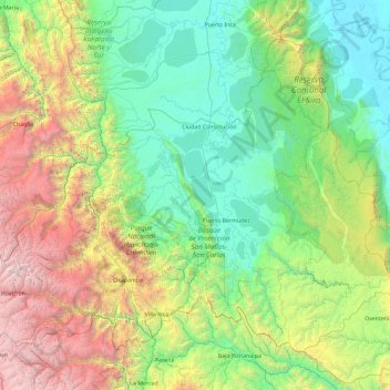
Nome: Mapa topográfico Province of Oxapampa, altitude, relevo.
Local: Province of Oxapampa, Pasco, 19230, Peru (-10.91260 -75.98550 -9.44570 -74.13203)
Altitude média: 1348 m
Altitude mínima: 152 m
Altitude máxima: 5332 m
The Oxapampa Province (Spanish: Provincia de Oxapampa) is the largest of three provinces that make up the Pasco Region in Peru. The capital of the Oxapampa province is the city of Oxapampa. The province is located on the eastern slopes of the Andes reaching down to the lowlands of the Amazon Basin. The high point of the province is approximately 5,300 metres (17,400 ft) in elevation near the summit of Huaguruncho mountain in the Huancabamba District and the low point is approximately 200 metres (660 ft) on the Pachitea River in the Constitución District.
Outros mapas topográficos
Clique em um mapa para visualizar sua topografia, sua altitude e seu relevo.
Orellana
Peru > Pasco > Constitución
Orellana, Constitución, Province of Oxapampa, Pasco, Peru
Altitude média: 241 m
Cerro de Pasco
Cerro de Pasco, Chaupimarca, Province of Pasco, Pasco, Peru
Altitude média: 4239 m
Villo
Peru > Pasco > Yanahuanca
Villo, Yanahuanca, Province of Daniel Carrión, Pasco, Peru
Altitude média: 3764 m