
Obrigado por apoiar este site ❤️
Faça uma doação
Faça uma doação
Prepare-se para a sua próxima aventura:
🕶️Óculos de Sol para Montanha - Lentes de alta proteção contra o encandeamento em altitudes elevadas
Como Associado da Amazon, este site recebe uma comissão sobre compras elegíveis sem custo adicional para si.
Mapa topográfico Chabahar
Clique no mapa para exibir a altitude.
Obrigado por apoiar este site ❤️
Faça uma doação
Faça uma doação
Prepare-se para a sua próxima aventura:
Como Associado da Amazon, este site recebe uma comissão sobre compras elegíveis sem custo adicional para si.
Sobre este mapa
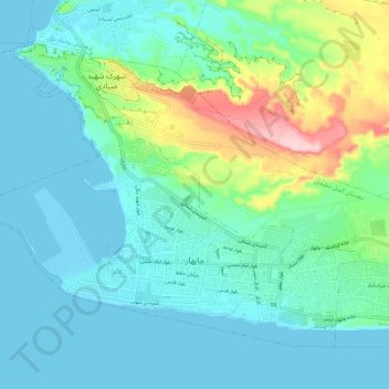
Nome: Mapa topográfico Chabahar, altitude, relevo.
Altitude média: 48 m
Altitude mínima: -1 m
Altitude máxima: 237 m
Obrigado por apoiar este site ❤️
Faça uma doação
Faça uma doação
Prepare-se para a sua próxima aventura:
Como Associado da Amazon, este site recebe uma comissão sobre compras elegíveis sem custo adicional para si.
Outros mapas topográficos
Clique em um mapa para visualizar sua topografia, sua altitude e seu relevo.
Shahdad Bazar
Iran > Sistan and Baluchestan Province > Chabahar County > دهستان پلان > Shahdad Bazar
Altitude média: 32 m