
Mapa topográfico Mount Marcy
Mapa interativo
Clique no mapa para exibir a altitude.
Sobre este mapa
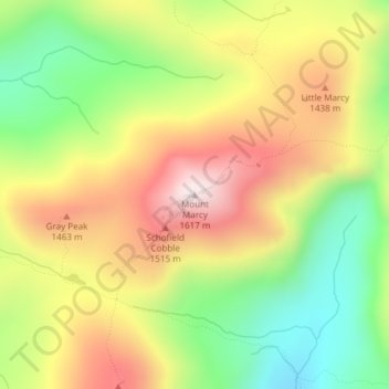
Nome: Mapa topográfico Mount Marcy, altitude, relevo.
Altitude média: 1289 m
Altitude mínima: 985 m
Altitude máxima: 1615 m
Mount Marcy (Mohawk: Tewawe’éstha) is the highest point in the U.S. state of New York, with an elevation of 5,343.1 feet (1,628.6 m). It is located in the Town of Keene in Essex County. The mountain is in the heart of the Adirondack High Peaks region of the High Peaks Wilderness Area. Its stature and expansive views make it a popular destination for hikers, who crowd its summit in the summer months.
Outros mapas topográficos
Clique em um mapa para visualizar sua topografia, sua altitude e seu relevo.
Cascade Mountain
United States > New York > Essex County > Town of Keene
Cascade Mountain, Cascade Mountain Trail, Town of Keene, Essex County, New York, United States
Altitude média: 946 m