
Mapa topográfico South Andaman
Mapa interativo
Clique no mapa para exibir a altitude.
Sobre este mapa
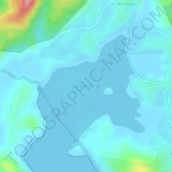
Nome: Mapa topográfico South Andaman, altitude, relevo.
Altitude média: 17 m
Altitude mínima: -3 m
Altitude máxima: 137 m
Outros mapas topográficos
Clique em um mapa para visualizar sua topografia, sua altitude e seu relevo.
Tarmugli Island
India > Andaman and Nicobar Islands > Ferrargunj
Tarmugli Island, Ferrargunj, South Andaman District, Andaman and Nicobar Islands, India
Altitude média: 4 m
North Sentinel Island
India > Andaman and Nicobar Islands > Ferrargunj
North Sentinel Island, Ferrargunj, South Andaman District, Andaman and Nicobar Islands, India
Altitude média: 20 m