
Faça uma doação
Prepare-se para a sua próxima aventura:
Como Associado da Amazon, este site recebe uma comissão sobre compras elegíveis sem custo adicional para si.
Mapa topográfico Mount Jefferson
Clique no mapa para exibir a altitude.
Faça uma doação
Prepare-se para a sua próxima aventura:
Como Associado da Amazon, este site recebe uma comissão sobre compras elegíveis sem custo adicional para si.
Mount Jefferson
The second tallest mountain in the U.S. state of Oregon after Mount Hood, Mount Jefferson lies within Jefferson, Linn, and Marion counties, in the central part of the state. Reaching an elevation of 10,497 feet (3,199 m), the volcano has a proximal relief of 4,890 feet (1,490 m). It is not usually visible from the city of Portland, though it is visible on clear days from Salem and can be noticed from highways to both the east and the west of the Cascade Range. The average elevation of the terrain around Jefferson is 5,500 to 6,500 feet (1,700 to 2,000 m), meaning that Jefferson's cone rises nearly 1 mile (1.6 km) above its surroundings.
Faça uma doação
Prepare-se para a sua próxima aventura:
Como Associado da Amazon, este site recebe uma comissão sobre compras elegíveis sem custo adicional para si.
Sobre este mapa
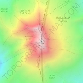
Nome: Mapa topográfico Mount Jefferson, altitude, relevo.
Local: Mount Jefferson, Jefferson County, Oregon, United States (44.67428 -121.79964 44.67438 -121.79954)
Altitude média: 2537 m
Altitude mínima: 2002 m
Altitude máxima: 3156 m
Faça uma doação
Prepare-se para a sua próxima aventura:
Como Associado da Amazon, este site recebe uma comissão sobre compras elegíveis sem custo adicional para si.
Outros mapas topográficos
Clique em um mapa para visualizar sua topografia, sua altitude e seu relevo.
Faça uma doação
Prepare-se para a sua próxima aventura:
Como Associado da Amazon, este site recebe uma comissão sobre compras elegíveis sem custo adicional para si.