
Mapa topográfico Nainital
Mapa interativo
Clique no mapa para exibir a altitude.
Sobre este mapa
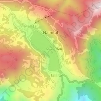
Nome: Mapa topográfico Nainital, altitude, relevo.
Local: Nainital, Nainital District, Uttarakhand, 263003, India (29.37263 79.43883 29.39879 79.46999)
Altitude média: 2059 m
Altitude mínima: 1562 m
Altitude máxima: 2449 m
Nainital is located in the Kumaon foothills of the outer Himalayas at a distance of 276 km (171 mi) from the state capital Dehradun and 314 km (195 mi) from New Delhi, the capital of India. Situated at an altitude of 1,938 metres (6,358 ft) above sea level, the town is set in a valley containing an eye-shaped lake, approximately two miles in circumference, and surrounded by mountains, of which the highest are Naina Peak (2,615 m (8,579 ft)) on the north, Deopatha (2,438 m (7,999 ft)) on the west, and Ayarpatha (2,278 m (7,474 ft)) on the south. From the tops of the higher peaks, "magnificent views can be obtained of the vast plain to the south, or of the mass of tangled ridges lying north, bound by the great snowy range which forms the central axis of the Himalayas." The hill station attracts tourists round the year.
Outros mapas topográficos
Clique em um mapa para visualizar sua topografia, sua altitude e seu relevo.
Khopi
India > Uttarakhand > Nainital > Bhumiyadhar
Khopi, Bhumiyadhar, Nainital, Nainital District, Uttarakhand, 263003, India
Altitude média: 1656 m
Naini Lake
India > Uttarakhand > Nainital > Nainital
Naini Lake, Talllital, Nainital, Nainital District, Uttarakhand, India
Altitude média: 2057 m
Kuleti
India > Uttarakhand > Nainital
Kuleti, Nainital, Nainital District, Uttarakhand, India
Altitude média: 1927 m
Hariyal
India > Uttarakhand > Nainital
Hariyal, Nainital, Nainital District, Uttarakhand, India
Altitude média: 1818 m
Maneri
India > Uttarakhand > Nainital
Maneri, Nainital, Nainital District, Uttarakhand, 236002, India
Altitude média: 1594 m
Bilaspur
India > Uttarakhand > Nainital
Bilaspur, Nainital, Uttarakhand, 263136, India
Altitude média: 1377 m
Sariya
India > Uttarakhand > Nainital > Char Khet
Sariya, Char Khet, Nainital, Uttarakhand, 263002, India
Altitude média: 1818 m
Bhimtal
India > Uttarakhand > Nainital
Bhimtal, Nainital, Uttarakhand, 263136, India
Altitude média: 1458 m
Bhowali
India > Uttarakhand > Nainital
Bhowali, Nainital, Uttarakhand, 263136, India
Altitude média: 1663 m