
Mapa topográfico Matinicus Island
Mapa interativo
Clique no mapa para exibir a altitude.
Sobre este mapa
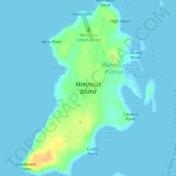
Nome: Mapa topográfico Matinicus Island, altitude, relevo.
Altitude média: 5 m
Altitude mínima: -1 m
Altitude máxima: 33 m
Matinicus Isle plantation is an archipelago located on the southeastern fringes of Penobscot Bay in the Gulf of Maine, part of the Atlantic Ocean. According to the United States Census Bureau, the plantation has a total area of 9.9 square miles (26 km2), of which 2.3 square miles (6.0 km2) is land and 7.6 square miles (20 km2) is water. Matinicus Island, the largest land mass in the archipelago, spans approximately 2 miles (3.2 km) in length and 1-mile (1.6 km) in width for an area of about 720 acres (290 ha). The elevation ranges from 0 to 100 feet (30.5 m). Matinicus Isle is located approximately 1 mile (1.6 km) north of Criehaven Isle.