
Mapa topográfico Cotswold District
Mapa interativo
Clique no mapa para exibir a altitude.
Sobre este mapa
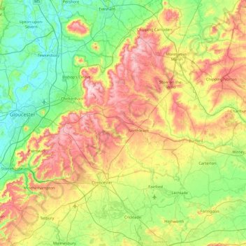
Nome: Mapa topográfico Cotswold District, altitude, relevo.
Local: Cotswold District, Gloucestershire, England, United Kingdom (51.57753 -2.32361 52.11258 -1.61520)
Altitude média: 118 m
Altitude mínima: 6 m
Altitude máxima: 328 m
Outros mapas topográficos
Clique em um mapa para visualizar sua topografia, sua altitude e seu relevo.
Highbury
United Kingdom > England > Gloucestershire > Forest of Dean > Lydney > Allaston
Highbury, Lydney, Allaston, Forest of Dean, Gloucestershire, England, GL15 5JQ, United Kingdom
Altitude média: 68 m