
Mapa topográfico McCall
Mapa interativo
Clique no mapa para exibir a altitude.
Sobre este mapa
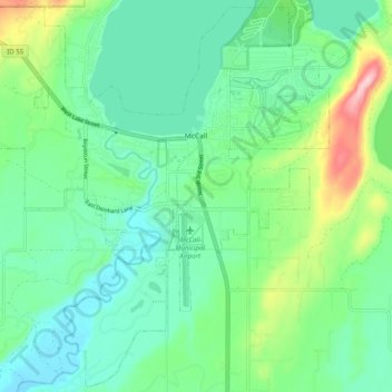
Nome: Mapa topográfico McCall, altitude, relevo.
Local: McCall, Valley County, Idaho, 83638, United States (44.86605 -116.16411 44.93408 -116.06501)
Altitude média: 1546 m
Altitude mínima: 1491 m
Altitude máxima: 1703 m
McCall is located at 44°54′39″N 116°6′11″W / 44.91083°N 116.10306°W / 44.91083; -116.10306 (44.910906, -116.103087),[7] at an elevation of 5,013 feet (1,528 m) above sea level.
Outros mapas topográficos
Clique em um mapa para visualizar sua topografia, sua altitude e seu relevo.
Yellow Pine
United States > Idaho > Valley County
Yellow Pine, Valley County, Idaho, 83677, United States
Altitude média: 1619 m
Buckhorn Summit
United States > Idaho > Valley County
Buckhorn Summit, Valley County, Idaho, United States
Altitude média: 2294 m
Chief
United States > Idaho > Valley County
Chief, Valley County, Idaho, United States
Altitude média: 2249 m
Marsh Creek
United States > Idaho > Valley County
Marsh Creek, Valley County, Idaho, United States
Altitude média: 2269 m