
Mapa topográfico Malaspina Glacier
Mapa interativo
Clique no mapa para exibir a altitude.
Sobre este mapa
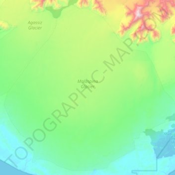
Nome: Mapa topográfico Malaspina Glacier, altitude, relevo.
Local: Malaspina Glacier, Yakutat, Alaska, United States (59.74222 -140.95854 60.13048 -140.14049)
Altitude média: 393 m
Altitude mínima: -3 m
Altitude máxima: 2086 m
The Malaspina is up to 600 meters (2,000 ft) thick in places, with the elevation of its bottom being estimated to be as much as 300 m (980 ft) below sea level.[4] There are two lakes on its margins: Oily Lake to the northwest, at the foot of the Samovar Hills between the Agassiz and Seward glaciers, and Malaspina Lake to the southeast, close to Yakutat Bay.
Outros mapas topográficos
Clique em um mapa para visualizar sua topografia, sua altitude e seu relevo.
Mount Saint Elias
United States > Alaska > Yakutat
Mount Saint Elias, Yakutat, Alaska, United States
Altitude média: 4672 m