
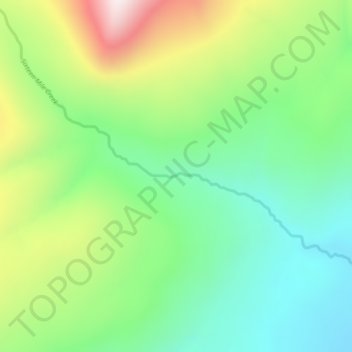
Mapa topográfico Sixteen Mile Creek
Mapa interativo
Clique no mapa para exibir a altitude.
Sobre este mapa
Nome: Mapa topográfico Sixteen Mile Creek, altitude, relevo.
Altitude média: 1267 m
Altitude mínima: 1027 m
Altitude máxima: 1711 m
Outros mapas topográficos
Clique em um mapa para visualizar sua topografia, sua altitude e seu relevo.
Beaver Lake
Canada > British Columbia > Regional District of Kitimat-Stikine > Area F (Dease Lake) > Dease Lake
Beaver Lake, Dease Lake, Area F (Dease Lake), Regional District of Kitimat-Stikine, British Columbia, Canada
Altitude média: 865 m
Dease Lake
Canada > British Columbia > Regional District of Kitimat-Stikine > Area F (Dease Lake)
Dease Lake, Area F (Dease Lake), Regional District of Kitimat-Stikine, British Columbia, V0C 1L0, Canada
Altitude média: 898 m
Ball Creek
Canada > British Columbia > Regional District of Kitimat-Stikine > Area F (Dease Lake)
Ball Creek, Area F (Dease Lake), Regional District of Kitimat-Stikine, British Columbia, Canada
Altitude média: 1267 m