
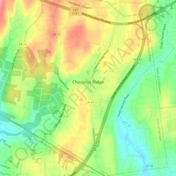
Mapa topográfico Village of Chestnut Ridge
Mapa interativo
Clique no mapa para exibir a altitude.
Sobre este mapa
Nome: Mapa topográfico Village of Chestnut Ridge, altitude, relevo.
Altitude média: 127 m
Altitude mínima: 80 m
Altitude máxima: 179 m
Outros mapas topográficos
Clique em um mapa para visualizar sua topografia, sua altitude e seu relevo.
Fort Clinton
United States > New York > Rockland County > Town of Stony Point
Fort Clinton, Town of Stony Point, Rockland County, New York, 10922, United States
Altitude média: 111 m
Buckberg
United States > New York > Rockland County > Town of Stony Point
Buckberg, Town of Stony Point, Rockland County, New York, 10986, United States
Altitude média: 108 m
Blauvelt
United States > New York > Rockland County
Blauvelt, Town of Orangetown, Rockland County, New York, 10913, United States
Altitude média: 63 m
Garnerville
United States > New York > Rockland County > Village of West Haverstraw
Garnerville, Village of West Haverstraw, Town of Haverstraw, Rockland County, New York, 10923, United States
Altitude média: 80 m
Antrim
United States > New York > Rockland County > Town of Ramapo > Village of Suffern
Antrim, Village of Suffern, Town of Ramapo, Rockland County, New York, 10901, United States
Altitude média: 140 m
Suffern
United States > New York > Rockland County > Suffern > Suffern
Suffern, Town of Ramapo, Rockland County, New York, 07495, United States
Altitude média: 159 m
Monsey
United States > New York > Rockland County
Monsey, Town of Ramapo, Rockland County, New York, 10952, United States
Altitude média: 172 m