
Mapa topográfico Keighley Moor Reservoir
Mapa interativo
Clique no mapa para exibir a altitude.
Sobre este mapa
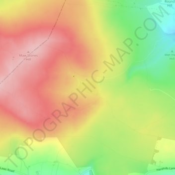
Nome: Mapa topográfico Keighley Moor Reservoir, altitude, relevo.
Altitude média: 366 m
Altitude mínima: 266 m
Altitude máxima: 439 m
Outros mapas topográficos
Clique em um mapa para visualizar sua topografia, sua altitude e seu relevo.
Ponden Reservoir
United Kingdom > England > Bradford > Keighley > Stanbury
Ponden Reservoir, Keighley, Stanbury, Bradford, West Yorkshire, England, United Kingdom
Altitude média: 313 m
Cackleshaw
United Kingdom > England > Bradford > Keighley > Oakworth > Cackleshaw
Cackleshaw, Keighley, Oakworth, Bradford, West Yorkshire, England, BD22 7JP, United Kingdom
Altitude média: 219 m
High Utley
United Kingdom > England > Bradford > Keighley > High Utley
High Utley, Keighley, Bradford, West Yorkshire, Yorkshire and the Humber, England, BD20 6ES, United Kingdom
Altitude média: 169 m