
Mapa topográfico Schmachtenhagen
Mapa interativo
Clique no mapa para exibir a altitude.
Sobre este mapa
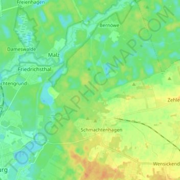
Nome: Mapa topográfico Schmachtenhagen, altitude, relevo.
Altitude média: 43 m
Altitude mínima: 31 m
Altitude máxima: 62 m
Outros mapas topográficos
Clique em um mapa para visualizar sua topografia, sua altitude e seu relevo.
Malz
Deutschland > Brandenburg > Oberhavel > Oranienburg
Malz, Oranienburg, Oberhavel, Brandenburg, Deutschland
Altitude média: 40 m
Bernöwe
Deutschland > Brandenburg > Oberhavel > Oranienburg
Bernöwe, Oranienburg, Oberhavel, Brandenburg, Deutschland
Altitude média: 41 m
Glashütte
Deutschland > Brandenburg > Oberhavel > Oranienburg > Fichtengrund
Glashütte, Fichtengrund, Oranienburg, Oberhavel, Brandenburg, 16515, Deutschland
Altitude média: 38 m
Germendorf
Deutschland > Brandenburg > Oberhavel > Oranienburg
Germendorf, Oranienburg, Oberhavel, Brandenburg, Deutschland
Altitude média: 41 m