
Mapa topográfico Dunblane
Clique no mapa para exibir a altitude.
Sobre este mapa
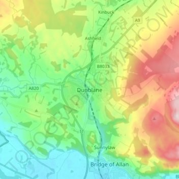
Nome: Mapa topográfico Dunblane, altitude, relevo.
Local: Dunblane, Stirling, Scotland, FK15 0AY, United Kingdom (56.14831 -4.00409 56.22831 -3.92409)
Altitude média: 117 m
Altitude mínima: 3 m
Altitude máxima: 328 m
Outros mapas topográficos
Clique em um mapa para visualizar sua topografia, sua altitude e seu relevo.
Loch Lomond and The Trossachs National Park
United Kingdom > Scotland > Stirling
The park straddles the Highland Boundary Fault, which divides it into two distinct regions - lowland and highland - that differ in underlying geology, soil types and topography. The change in rock type can most clearly be seen at Loch Lomond itself, as the fault runs across the islands of Inchmurrin, Creinch,…
Altitude média: 291 m