
Mapa topográfico Engwegen
Mapa interativo
Clique no mapa para exibir a altitude.
Sobre este mapa
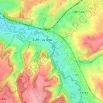
Nome: Mapa topográfico Engwegen, altitude, relevo.
Altitude média: 120 m
Altitude mínima: 69 m
Altitude máxima: 174 m
Outros mapas topográficos
Clique em um mapa para visualizar sua topografia, sua altitude e seu relevo.
Oud-Valkenburg
Nederland > Limburg > Schin op Geul
Oud-Valkenburg, Schin op Geul, Valkenburg aan de Geul, Limburg, Nederland, 6305 AB, Nederland
Altitude média: 117 m
Schoonbron
Nederland > Limburg > Schin op Geul
Schoonbron, Schin op Geul, Valkenburg aan de Geul, Limburg, Nederland, 6305 PR, Nederland
Altitude média: 121 m