
Mapa topográfico Huangshan
Mapa interativo
Clique no mapa para exibir a altitude.
Huangshan
The vegetation of the area varies with elevation. Mesic forests cover the landscape below 1,100 meters. Deciduous forest stretches from 1,100 meters up to the tree line at 1,800 meters. Above that point, the vegetation consists of alpine grasslands. The area has diverse flora, where one-third of China's bryophyte families and more than half of its fern families are represented. The Huangshan pine (Pinus hwangshanensis) is named after Huangshan and is considered an example of vigor because the trees thrive by growing straight out of the rocks.[7] Many of the pine trees in the area are more than a hundred years old and have been given their own names (such as the Ying Ke Pine, or Welcoming-Guests Pine, which is thought to be more than 1500 years old).[5] The pines vary greatly in shape and size, with the most crooked of the trees being considered the most attractive.[8] Furthermore, Huangshan's moist climate facilitates the growing of tea leaves[9] and the mountain has been called "one of China's premier green tea-growing mountains.[10] Mao feng cha ("Fur Peak Tea"), a well-known local variety of green tea,[11] takes its name from the downy tips of tea leaves found in the Huangshan area.[12]
Sobre este mapa
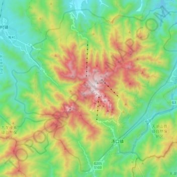
Nome: Mapa topográfico Huangshan, altitude, relevo.
Altitude média: 754 m
Altitude mínima: 196 m
Altitude máxima: 1809 m
Outros mapas topográficos
Clique em um mapa para visualizar sua topografia, sua altitude e seu relevo.