
Mapa topográfico Rüthi (SG)
Mapa interativo
Clique no mapa para exibir a altitude.
Sobre este mapa
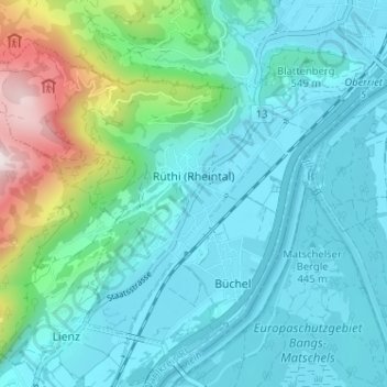
Nome: Mapa topográfico Rüthi (SG), altitude, relevo.
Local: Rüthi (SG), Wahlkreis Rheintal, St. Gallen, Switzerland (47.27661 9.50149 47.31048 9.56558)
Altitude média: 594 m
Altitude mínima: 410 m
Altitude máxima: 1412 m
Outros mapas topográficos
Clique em um mapa para visualizar sua topografia, sua altitude e seu relevo.
Oberriet
Switzerland > St. Gallen > Wahlkreis Rheintal
Oberriet, Wahlkreis Rheintal, St. Gallen, Switzerland
Altitude média: 528 m
Berneck
Switzerland > St. Gallen > Wahlkreis Rheintal
Berneck, Wahlkreis Rheintal, St. Gallen, 9442, Switzerland
Altitude média: 561 m
Altstätten
Switzerland > St. Gallen > Wahlkreis Rheintal > Altstätten
Altstätten, Wahlkreis Rheintal, St. Gallen, Switzerland
Altitude média: 679 m
Marbach
Switzerland > St. Gallen > Wahlkreis Rheintal > Marbach
Marbach, Wahlkreis Rheintal, St. Gallen, 9437, Switzerland
Altitude média: 448 m