
Mapa topográfico Nagaur
Mapa interativo
Clique no mapa para exibir a altitude.
Sobre este mapa
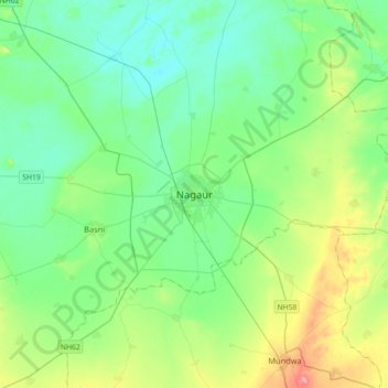
Nome: Mapa topográfico Nagaur, altitude, relevo.
Altitude média: 303 m
Altitude mínima: 278 m
Altitude máxima: 376 m
Nagaur is located at 27°12′N 73°44′E / 27.2°N 73.73°E / 27.2; 73.73. It has an average elevation of 302 metres (990 feet). Nagaur is situated amidst seven districts namely Bikaner, Churu, Sikar, Jaipur, Ajmer, Pali, Jodhpur. Nagaur is the fifth largest district in Rajasthan with a vast terrain spreading over 17,718 km2 (6,841 sq mi) Its geographical spread is a good combine of plain, hills, sand mounds and as such it is a part of the great Indian Thar Desert.
Outros mapas topográficos
Clique em um mapa para visualizar sua topografia, sua altitude e seu relevo.
Gogelao
India > Rajasthan > Nagaur Tehsil > Gogelao
Gogelao, Nagaur Tehsil, Nagaur, Rajasthan, India
Altitude média: 298 m