
Mapa topográfico Shennongjia
Mapa interativo
Clique no mapa para exibir a altitude.
Sobre este mapa
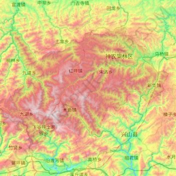
Nome: Mapa topográfico Shennongjia, altitude, relevo.
Local: Shennongjia, Hubei, China (31.29862 109.93621 31.86261 110.97283)
Altitude média: 1280 m
Altitude mínima: 140 m
Altitude máxima: 3067 m
Shennongjia Forestry District is named after the Shennongjia mountainous massif, which is usually considered to be the eastern (and the highest) section of the Daba Mountains (Daba Shan). It lies within the Daba Mountains evergreen forests ecoregion. Some of Hubei's highest mountains - which are also the highest mountains of the Daba Shan - are located within the district. The three tallest peaks, located west of Muyu town, are Shennong Deng (3,105 metres (10,187 ft) elevation), Da Shennongjia (3,052 metres (10,013 ft)), and Xiao Shennongjia (3,005 metres (9,859 ft), on the border with Badong County). Laojun Shan, 2,936 metres (9,633 ft) tall, is located northeast of Muyu.
Outros mapas topográficos
Clique em um mapa para visualizar sua topografia, sua altitude e seu relevo.
Xiaowan Subdistrict
Xiaowan Subdistrict, Xiangzhou District, Xiangyang, Hubei, China
Altitude média: 79 m
Huolongping
China > Hubei > Xianfeng County
Huolongping, Xianfeng County, Enshi Tujia and Miao Autonomous Prefecture, Hubei, 445600, China
Altitude média: 914 m
Wuhan Botanical Garden, Chinese Academy of Sciences
China > Hubei > Hongshan District
Wuhan Botanical Garden, Chinese Academy of Sciences, 东湖生态旅游风景区(托管), Hongshan District, Wuhan, Hubei, 430074, China
Altitude média: 29 m
Huanggang
China > Hubei > Huangmei County > Huanggang
Huanggang, Huangmei County, Hubei, China
Altitude média: 75 m
Jiang'an District
China > Hubei > Jiang'an District
Jiang'an District, Hubei, 430062, China
Altitude média: 25 m
Changyang Tujia Autonomous County
China > Hubei > Changyang Tujia Autonomous County
Changyang Tujia Autonomous County, Yichang, Hubei, China
Altitude média: 483 m
Gucheng Subdistrict
China > Hubei > Xiangyang > Gucheng Subdistrict
Gucheng Subdistrict, Xiangcheng District, Xiangyang, Hubei, China
Altitude média: 68 m
Three Gorges Dam
China > Hubei > Yichang > Sandouping
Three Gorges Dam, Sandouping, Yichang, Yiling District, Hubei, China
Altitude média: 96 m
Sandouping
China > Hubei > Yichang > Sandouping
Sandouping, Yiling District, Yichang, Hubei, China
Altitude média: 259 m
Xiling District
China > Hubei > Xiling District
Xiling District, Yichang, Hubei, 443005, China
Altitude média: 232 m
Xianning City
China > Hubei > Xianning City
Xianning, Xian'an District, Xianning City, Hubei, China
Altitude média: 90 m