
Mapa topográfico Murfreesboro
Mapa interativo
Clique no mapa para exibir a altitude.
Sobre este mapa
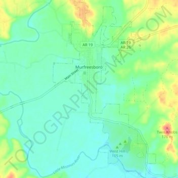
Nome: Mapa topográfico Murfreesboro, altitude, relevo.
Local: Murfreesboro, Pike County, Arkansas, 71958, United States (34.02077 -93.70617 34.08725 -93.65972)
Altitude média: 114 m
Altitude mínima: 93 m
Altitude máxima: 168 m
Outros mapas topográficos
Clique em um mapa para visualizar sua topografia, sua altitude e seu relevo.
Crater of Diamonds State Park
United States > Arkansas > Pike County > Murfreesboro > Kimberley
Crater of Diamonds State Park, Kimberley, Murfreesboro, Pike County, Arkansas, 71958, United States
Altitude média: 106 m
Little Missouri River
United States > Arkansas > Pike County
Little Missouri River, Pike County, Arkansas, 71958, United States
Altitude média: 159 m
Antoine
United States > Arkansas > Pike County
Antoine, Pike County, Arkansas, United States
Altitude média: 90 m
Glenwood
United States > Arkansas > Pike County > Glenwood
Glenwood, Pike County, Arkansas, United States
Altitude média: 193 m
Delight
United States > Arkansas > Pike County > Delight
Delight, Pike County, Arkansas, 71940, United States
Altitude média: 119 m
Lake Greeson
United States > Arkansas > Pike County
Lake Greeson, Pike County, Arkansas, 71950, United States
Altitude média: 195 m