
Mapa topográfico Arbaz
Mapa interativo
Clique no mapa para exibir a altitude.
Sobre este mapa
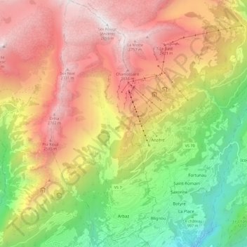
Nome: Mapa topográfico Arbaz, altitude, relevo.
Local: Arbaz, Sion, Wallis, 1974, Switzerland (46.26372 7.35024 46.34049 7.39863)
Altitude média: 1720 m
Altitude mínima: 535 m
Altitude máxima: 2883 m
The municipality is located in the Sion district, at an elevation of between 830 and 2,886 m (2,723 and 9,469 ft). Until 1877 it was part of the municipality of Ayent. The village of Arbaz was partially destroyed by fire in 1924, but has been rebuilt. Almost half of the houses in the village are vacation homes. It is situated on the north bank of the Rhône River.
Outros mapas topográficos
Clique em um mapa para visualizar sua topografia, sua altitude e seu relevo.
Sex Noir
Switzerland > Wallis > Sion > Arbaz
Sex Noir, Arbaz, Sion, Wallis, 1974, Switzerland
Altitude média: 2290 m
Veysonnaz
Switzerland > Wallis > Sion
Veysonnaz, Sion, Wallis, 1993, Switzerland
Altitude média: 1020 m
Les Mountons
Switzerland > Wallis > Sion > Savièse
Les Mountons, Savièse, Sion, Wallis, 1965, Switzerland
Altitude média: 2228 m