
Mapa topográfico San Luis Potosí
Mapa interativo
Clique no mapa para exibir a altitude.
Sobre este mapa
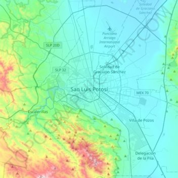
Nome: Mapa topográfico San Luis Potosí, altitude, relevo.
Altitude média: 2004 m
Altitude mínima: 1826 m
Altitude máxima: 2855 m
San Luis Potosí, commonly called SLP or simply San Luis, is the capital and the most populous city of the Mexican state of San Luis Potosí. It is the municipal seat of the surrounding municipality of San Luis Potosí. The city lies at an elevation of 1,864 metres (6,115 feet). It has an estimated population of 824,229 in the city proper and a population of approximately 1,221,526 in its metropolitan area, formed with the neighbour city of Soledad de Graciano Sánchez and other surrounding municipalities, which makes the metropolitan area of Greater San Luis Potosí the eleventh largest in Mexico.
Outros mapas topográficos
Clique em um mapa para visualizar sua topografia, sua altitude e seu relevo.
Rotonda Florida
Mexico > San Luis Potosi > Municipio de San Luis Potosí
Rotonda Florida, Bosques La Florida, Municipio de San Luis Potosí, San Luis Potosi, Mexico
Altitude média: 1853 m