
Faça uma doação
Prepare-se para a sua próxima aventura:
Como Associado da Amazon, este site recebe uma comissão sobre compras elegíveis sem custo adicional para si.
Mapa topográfico Palembang
Clique no mapa para exibir a altitude.
Faça uma doação
Prepare-se para a sua próxima aventura:
Como Associado da Amazon, este site recebe uma comissão sobre compras elegíveis sem custo adicional para si.
Palembang
At 2°59′10″S 104°45′20″E / 2.98611°S 104.75556°E / -2.98611; 104.75556, Palembang occupies 400.61 km2 of vast lowland area east of Bukit Barisan Mountains in southern Sumatra with average elevation of 8 metres (26 feet), approximately 105 kilometres (65 miles) from nearby coast at Bangka Strait. One of the largest rivers in Sumatra, the Musi River, runs through the city, dividing the city area into two major parts which are Seberang Ilir in the north and Seberang Ulu in the south. Palembang is also located on the confluence of two major tributaries of Musi River, which are Ogan River and Komering River. The river's water level is influenced by tidal cycle. In rainy season, many areas on the city are inundated by the river's tide.
Faça uma doação
Prepare-se para a sua próxima aventura:
Como Associado da Amazon, este site recebe uma comissão sobre compras elegíveis sem custo adicional para si.
Sobre este mapa
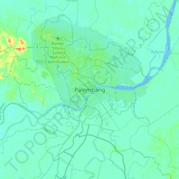
Nome: Mapa topográfico Palembang, altitude, relevo.
Local: Palembang, South Sumatra, 30267, Indonesia (-3.14883 104.59686 -2.82883 104.91686)
Altitude média: 6 m
Altitude mínima: 0 m
Altitude máxima: 51 m
Faça uma doação
Prepare-se para a sua próxima aventura:
Como Associado da Amazon, este site recebe uma comissão sobre compras elegíveis sem custo adicional para si.
Outros mapas topográficos
Clique em um mapa para visualizar sua topografia, sua altitude e seu relevo.
Faça uma doação
Prepare-se para a sua próxima aventura:
Como Associado da Amazon, este site recebe uma comissão sobre compras elegíveis sem custo adicional para si.
Faça uma doação
Prepare-se para a sua próxima aventura:
Como Associado da Amazon, este site recebe uma comissão sobre compras elegíveis sem custo adicional para si.
Faça uma doação
Prepare-se para a sua próxima aventura:
Como Associado da Amazon, este site recebe uma comissão sobre compras elegíveis sem custo adicional para si.