
Mapa topográfico Winlock
Mapa interativo
Clique no mapa para exibir a altitude.
Sobre este mapa
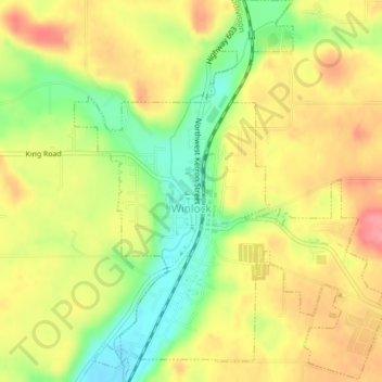
Nome: Mapa topográfico Winlock, altitude, relevo.
Local: Winlock, Lewis County, Washington, United States (46.48013 -122.95086 46.50712 -122.91892)
Altitude média: 124 m
Altitude mínima: 78 m
Altitude máxima: 162 m
The eastern edge of the Willapa Hills lie to the west. To the east are relatively flat prairies. A notable landmark about four miles west of town is Sam Henry Mountain, elevation 1,492 feet (455 m), named for an early section superintendent of the Northern Pacific Railroad. Mt. St. Helens, about forty miles (64.4 km) to the east can be seen from viewpoints around the area. In May 1980, Winlock was covered with about one inch (2.54 cm) of volcanic ash from the second major eruption of this peak one week after the cataclysmic eruption of May 18.
Outros mapas topográficos
Clique em um mapa para visualizar sua topografia, sua altitude e seu relevo.
Ceres
United States > Washington > Lewis County
Ceres, Lewis County, Washington, United States
Altitude média: 123 m
Toledo
United States > Washington > Lewis County
Toledo, Lewis County, Washington, United States
Altitude média: 49 m
Riffe Lake
United States > Washington > Lewis County
Riffe Lake, Lewis County, Washington, United States
Altitude média: 503 m
Mossyrock
United States > Washington > Lewis County
Mossyrock, Lewis County, Washington, United States
Altitude média: 213 m
Ike Kinswa State Park
United States > Washington > Lewis County
Ike Kinswa State Park, Lewis County, Washington, United States
Altitude média: 187 m
Chehalis
United States > Washington > Lewis County
Chehalis, Lewis County, Washington, United States
Altitude média: 81 m
Centralia
United States > Washington > Lewis County
Centralia, Lewis County, Washington, United States
Altitude média: 74 m
Ham Hill
United States > Washington > Lewis County > Centralia
Ham Hill, Centralia, Lewis County, Washington, United States
Altitude média: 101 m
The Rockies
United States > Washington > Lewis County
The Rockies, Lewis County, Washington, United States
Altitude média: 1012 m
Napavine
United States > Washington > Lewis County > Napavine
Napavine, Lewis County, Washington, 98565, United States
Altitude média: 105 m
Onalaska
United States > Washington > Lewis County
Onalaska, Lewis County, Washington, 98542, United States
Altitude média: 170 m