
Mapa topográfico Vesoul
Mapa interativo
Clique no mapa para exibir a altitude.
Sobre este mapa
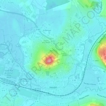
Nome: Mapa topográfico Vesoul, altitude, relevo.
Altitude média: 232 m
Altitude mínima: 213 m
Altitude máxima: 369 m
Vesoul is first mentioned in a document dated 899. That document speaks about an elevation with a fortified watchtower. The document speaks about "Castrum Vesulium". Castrum is a fortification, and "Vesulium" has the syllable ves which meant hill or mountain in a language that was spoken before the Celts. Today, there is a castle that forms the centre of the city. The first houses were built inside the walls of the castle. Newcomers who found no place settled outside the city walls, on the flanks of the hill. Growing wine was popular.
Outros mapas topográficos
Clique em um mapa para visualizar sua topografia, sua altitude e seu relevo.
La Vaivre
France > Bourgogne-Franche-Comté > Haute-Saône
La Vaivre, Lure, Haute-Saône, Bourgogne-Franche-Comté, Metropolitan France, 70320, France
Altitude média: 325 m
Saint-Sauveur
France > Bourgogne-Franche-Comté > Haute-Saône
Saint-Sauveur, Lure, Haute-Saône, Bourgogne-Franche-Comté, Metropolitan France, 70300, France
Altitude média: 284 m
La Montagne
France > Bourgogne-Franche-Comté > Haute-Saône
La Montagne, Lure, Haute-Saône, Bourgogne-Franche-Comté, Metropolitan France, 70310, France
Altitude média: 721 m
Villers-la-Ville
France > Bourgogne-Franche-Comté > Haute-Saône > Villers-la-Ville
Villers-la-Ville, Lure, Haute-Saône, Bourgogne-Franche-Comté, Metropolitan France, 70110, France
Altitude média: 286 m
La Romaine
France > Bourgogne-Franche-Comté > Haute-Saône > La Romaine
La Romaine, Vesoul, Haute-Saône, Bourgogne-Franche-Comté, Metropolitan France, 70130, France
Altitude média: 236 m
Vars
France > Bourgogne-Franche-Comté > Haute-Saône
Vars, Vesoul, Haute-Saône, Bourgogne-Franche-Comté, Metropolitan France, 70600, France
Altitude média: 244 m
Bay
France > Bourgogne-Franche-Comté > Haute-Saône
Bay, Vesoul, Haute-Saône, Bourgogne-Franche-Comté, Metropolitan France, 70150, France
Altitude média: 244 m
Fallon
France > Bourgogne-Franche-Comté > Haute-Saône
Fallon, Lure, Haute-Saône, Bourgogne-Franche-Comté, Metropolitan France, 70110, France
Altitude média: 376 m
Fougerolles
France > Bourgogne-Franche-Comté > Haute-Saône > Fougerolles-Saint-Valbert
Fougerolles, Fougerolles-Saint-Valbert, Lure, Haute-Saône, Bourgogne-Franche-Comté, Metropolitan France, 70220, France
Altitude média: 399 m
La Rosière
France > Bourgogne-Franche-Comté > Haute-Saône
La Rosière, Lure, Haute-Saône, Bourgogne-Franche-Comté, Metropolitan France, 70310, France
Altitude média: 627 m
Clans
France > Bourgogne-Franche-Comté > Haute-Saône
Clans, Vesoul, Haute-Saône, Bourgogne-Franche-Comté, Metropolitan France, 70000, France
Altitude média: 247 m
Lure
France > Bourgogne-Franche-Comté > Haute-Saône > Lure
Lure, Haute-Saône, Bourgogne-Franche-Comté, Metropolitan France, 70200, France
Altitude média: 304 m
Ronchamp
France > Bourgogne-Franche-Comté > Haute-Saône
Ronchamp, Lure, Haute-Saône, Bourgogne-Franche-Comté, Metropolitan France, 70250, France
Altitude média: 444 m
Luxeuil-les-Bains
France > Bourgogne-Franche-Comté > Haute-Saône
Luxeuil-les-Bains, Lure, Haute-Saône, Bourgogne-Franche-Comté, Metropolitan France, 70300, France
Altitude média: 320 m