
Mapa topográfico Coachella Valley
Mapa interativo
Clique no mapa para exibir a altitude.
Sobre este mapa
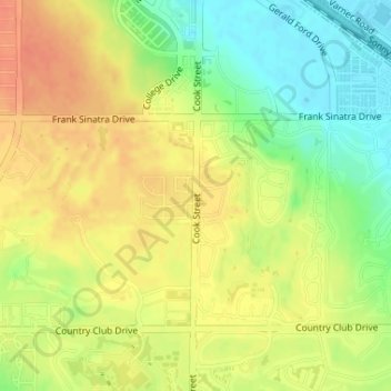
Nome: Mapa topográfico Coachella Valley, altitude, relevo.
Altitude média: 72 m
Altitude mínima: 47 m
Altitude máxima: 91 m
The area is surrounded on the southwest by the Santa Rosa Mountains, by the San Jacinto Mountains to the west, the Little San Bernardino Mountains to the east and San Gorgonio Mountain to the north. These mountains peak at around 11,000 feet (3,400 m) and tend to average between 5,000 and 7,000 feet (1,500 and 2,100 m). Elevations on the Valley floor range from 1,600 feet (490 m) above sea level at the north end of the Valley to 250 feet (76 m) below sea level around Mecca.
Outros mapas topográficos
Clique em um mapa para visualizar sua topografia, sua altitude e seu relevo.
Bermuda Dunes
United States > California > Riverside County > Palm Desert
Bermuda Dunes, Palm Desert, Riverside County, CAL Fire Southern Region, California, United States
Altitude média: 27 m
Palm Desert
United States > California > Riverside County > Palm Desert
Palm Desert, Riverside County, California, United States
Altitude média: 142 m
Cahuilla Hills
United States > California > Riverside County > Palm Desert
Cahuilla Hills, Palm Desert, Riverside County, California, 92770, United States
Altitude média: 369 m