
Mapa topográfico New Stanton
Mapa interativo
Clique no mapa para exibir a altitude.
Sobre este mapa
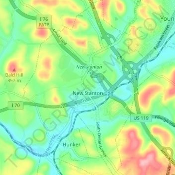
Nome: Mapa topográfico New Stanton, altitude, relevo.
Altitude média: 325 m
Altitude mínima: 278 m
Altitude máxima: 410 m
Outros mapas topográficos
Clique em um mapa para visualizar sua topografia, sua altitude e seu relevo.
Stanton Heights
United States > Pennsylvania > Westmoreland County > New Stanton > Stanton Heights
Stanton Heights, New Stanton, Westmoreland County, Pennsylvania, 15639, United States
Altitude média: 327 m
Paintersville
United States > Pennsylvania > Westmoreland County > New Stanton > Paintersville
Paintersville, New Stanton, Westmoreland County, Pennsylvania, 15672, United States
Altitude média: 324 m