
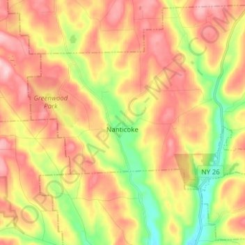
Mapa topográfico Town of Nanticoke
Mapa interativo
Clique no mapa para exibir a altitude.
Sobre este mapa
Nome: Mapa topográfico Town of Nanticoke, altitude, relevo.
Altitude média: 396 m
Altitude mínima: 288 m
Altitude máxima: 489 m
Outros mapas topográficos
Clique em um mapa para visualizar sua topografia, sua altitude e seu relevo.
Town of Binghamton
United States > New York > Broome County
Town of Binghamton, Broome County, New York, 13903, United States
Altitude média: 417 m
Crocker Island
United States > New York > Broome County > Village of Johnson City
Crocker Island, Village of Johnson City, Town of Union, Broome County, New York, 13902, United States
Altitude média: 411 m
Nineveh
United States > New York > Broome County
Nineveh, Town of Colesville, Broome County, New York, United States
Altitude média: 338 m
City of Binghamton
United States > New York > Broome County
City of Binghamton, Broome County, New York, 13905, United States
Altitude média: 321 m
Oquaga Lake
United States > New York > Broome County > Town of Sanford
Oquaga Lake, Town of Sanford, Broome County, New York, United States
Altitude média: 515 m
Binghamton
United States > New York > Broome County > Binghamton
Binghamton, Broome County, New York, 13903, United States
Altitude média: 397 m
Town of Vestal
United States > New York > Broome County
Town of Vestal, Union, Broome County, New York, United States
Altitude média: 372 m
Village of Johnson City
United States > New York > Broome County
Village of Johnson City, Town of Union, Broome County, New York, 13790, United States
Altitude média: 309 m
Flowers
United States > New York > Broome County > Flowers
Flowers, Windsor Town, Broome County, New York, 13865, United States
Altitude média: 484 m
Village of Deposit
United States > New York > Broome County
Village of Deposit, Town of Sanford, Broome County, New York, United States
Altitude média: 356 m