
Mapa topográfico Picton
Mapa interativo
Clique no mapa para exibir a altitude.
Sobre este mapa
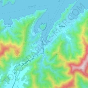
Nome: Mapa topográfico Picton, altitude, relevo.
Local: Picton, Marlborough, 7220, New Zealand (-41.33092 173.96691 -41.25092 174.04691)
Altitude média: 193 m
Altitude mínima: -1 m
Altitude máxima: 951 m
On the land side, Picton is surrounded by hills and mountains, including Te Tara-o-Te-Marama/Mount Freeth to the west, the Robertson Range to the south and Mount McCormick to the east. The Elevation Saddle connects southwest of the town with the Tuamarina River valley and contains the main land transport routes between Picton and the rest of the South Island.
Outros mapas topográficos
Clique em um mapa para visualizar sua topografia, sua altitude e seu relevo.
Rousehill Reserve
New Zealand > Marlborough > Renwick
Rousehill Reserve, Renwick, Marlborough, New Zealand
Altitude média: 43 m
Duncan Bay
New Zealand > Marlborough > Duncan Bay
Duncan Bay, Marlborough, New Zealand
Altitude média: 173 m
Mount Richmond
Mount Richmond, Marlborough, New Zealand
Altitude média: 1262 m