
Mapa topográfico Raggettstown
Mapa interativo
Clique no mapa para exibir a altitude.
Sobre este mapa
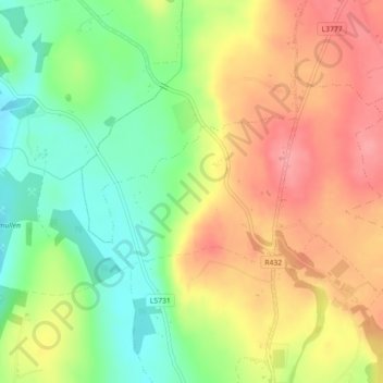
Nome: Mapa topográfico Raggettstown, altitude, relevo.
Altitude média: 147 m
Altitude mínima: 100 m
Altitude máxima: 192 m
Outros mapas topográficos
Clique em um mapa para visualizar sua topografia, sua altitude e seu relevo.
Portlaoise
Portlaoise, The Municipal District of Portlaoise, County Laois, Leinster, Ireland
Altitude média: 101 m
Kilmainham
Kilmainham, Shaen ED, The Municipal District of Portlaoise, County Laois, Leinster, Ireland
Altitude média: 80 m
Portarlington
Portarlington, County Laois, Leinster, Ireland
Altitude média: 70 m
Ballyroan
Ballyroan, Ballyroan ED, The Municipal District of Portlaoise, County Laois, Leinster, Ireland
Altitude média: 134 m
Clonaslee
Clonaslee, Clonaslee ED, The Municipal District of Borris-in-Ossory — Mountmellick, County Laois, Leinster, Ireland
Altitude média: 117 m
Ballycullenbeg
Ballycullenbeg, Mountmellick Urban ED, The Municipal District of Borris-in-Ossory — Mountmellick, County Laois, Leinster, Ireland
Altitude média: 76 m
Boherard
Boherard, Cuffsborough ED, The Municipal District of Borris-in-Ossory — Mountmellick, County Laois, Leinster, Ireland
Altitude média: 118 m
Ballynagarr
Ballynagarr, Killabban ED, The Municipal District of Graiguecullen — Portarlington, County Laois, Leinster, Ireland
Altitude média: 64 m
Kellyville
Kellyville, Ballyadams ED, The Municipal District of Graiguecullen — Portarlington, County Laois, Leinster, Ireland, Kellyville Lake
Altitude média: 83 m
Kellyville
Kellyville, Ballyadams ED, The Municipal District of Graiguecullen — Portarlington, County Laois, Leinster, Ireland
Altitude média: 102 m
Durrow
Durrow, Durrow ED, The Municipal District of Borris-in-Ossory — Mountmellick, County Laois, Leinster, Ireland
Altitude média: 93 m
Killabban
Killabban, Killabban ED, The Municipal District of Graiguecullen — Portarlington, County Laois, Leinster, Ireland
Altitude média: 62 m
The Municipal District of Graiguecullen — Portarlington
The Municipal District of Graiguecullen — Portarlington, County Laois, Leinster, Ireland
Altitude média: 113 m
Brandra
Brandra, Abbeyleix ED, The Municipal District of Portlaoise, County Laois, Leinster, Ireland
Altitude média: 100 m
Stradbally
Stradbally, Stradbally ED, The Municipal District of Graiguecullen — Portarlington, County Laois, Leinster, Ireland
Altitude média: 92 m
Rathronshin
Rathronshin, Sallyford ED, The Municipal District of Graiguecullen — Portarlington, County Laois, Leinster, Ireland
Altitude média: 69 m
Kilfeacle
Kilfeacle, Rathaspick ED, The Municipal District of Graiguecullen — Portarlington, County Laois, Leinster, Ireland
Altitude média: 212 m
The Municipal District of Borris-in-Ossory — Mountmellick
The Municipal District of Borris-in-Ossory — Mountmellick, County Laois, Leinster, Ireland
Altitude média: 132 m
Glasha
Glasha, Vicarstown ED, The Municipal District of Graiguecullen — Portarlington, County Laois, Leinster, Ireland
Altitude média: 58 m
Raheennahown
Raheennahown, Luggacurren ED, The Municipal District of Graiguecullen — Portarlington, County Laois, Leinster, Ireland
Altitude média: 134 m
Mountrath
Mountrath, Mountrath ED, The Municipal District of Borris-in-Ossory — Mountmellick, County Laois, Leinster, Ireland
Altitude média: 107 m
Rossmore
Rossmore, Moyanna ED, The Municipal District of Graiguecullen — Portarlington, County Laois, Leinster, Ireland
Altitude média: 69 m
Cullenagh Mountain
Cullenagh Mountain, The Municipal District of Portlaoise, County Laois, Leinster, Ireland
Altitude média: 226 m
Sconce Upper
Sconce Upper, Brisha ED, The Municipal District of Borris-in-Ossory — Mountmellick, County Laois, Leinster, Ireland
Altitude média: 235 m
Ballyfin Upper
Ballyfin Upper, Ballyfin ED, The Municipal District of Borris-in-Ossory — Mountmellick, County Laois, Leinster, Ireland
Altitude média: 220 m
Portarlington
Ireland > County Laois > Portarlington
Portarlington, The Municipal District of Graiguecullen — Portarlington, County Laois, Leinster, R32 TR72, Ireland
Altitude média: 72 m
The Municipal District of Portlaoise
The Municipal District of Portlaoise, County Laois, Leinster, Ireland
Altitude média: 138 m
Boley Upper
Boley Upper, Clash ED, The Municipal District of Borris-in-Ossory — Mountmellick, County Laois, Leinster, Ireland
Altitude média: 98 m
Carrowreagh and Derreen
Carrowreagh and Derreen, Aughmacart ED, The Municipal District of Borris-in-Ossory — Mountmellick, County Laois, Leinster, Ireland
Altitude média: 86 m
Killeshin
Killeshin, Ballickmoyler ED, The Municipal District of Graiguecullen — Portarlington, County Laois, Leinster, Ireland
Altitude média: 89 m
Timahoe Round Tower
Timahoe Round Tower, L7797, Timahoe ED, The Municipal District of Graiguecullen — Portarlington, County Laois, Leinster, Ireland
Altitude média: 137 m
Portlaoise
Ireland > County Laois > Portlaoise
Portlaoise, The Municipal District of Portlaoise, County Laois, Leinster, R32 DX07, Ireland
Altitude média: 107 m
Ballinakill
Ireland > County Laois > Ballinakill
Ballinakill, The Municipal District of Portlaoise, County Laois, Leinster, Ireland
Altitude média: 139 m
Ballybrophy
Ballybrophy, The Municipal District of Borris-in-Ossory — Mountmellick, County Laois, Leinster, R32 H773, Ireland
Altitude média: 124 m