
Mapa topográfico Pocatello
Mapa interativo
Clique no mapa para exibir a altitude.
Sobre este mapa
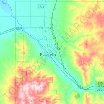
Nome: Mapa topográfico Pocatello, altitude, relevo.
Local: Pocatello, Bannock County, Idaho, United States (42.80215 -112.63186 42.93149 -112.36026)
Altitude média: 1580 m
Altitude mínima: 1328 m
Altitude máxima: 2209 m
Pocatello is the fifth-largest city in the state, just behind Idaho Falls. In 2007, Pocatello was ranked twentieth on Forbes list of Best Small Places for Business and Careers. Pocatello is the home of Idaho State University and the manufacturing facility of ON Semiconductor. The city is at an elevation of 4,462 feet (1,360 m) above sea level and is served by the Pocatello Regional Airport.
Outros mapas topográficos
Clique em um mapa para visualizar sua topografia, sua altitude e seu relevo.
Downey
United States > Idaho > Bannock County
Downey, Bannock County, Idaho, United States
Altitude média: 1482 m
Fort Hall
United States > Idaho > Bannock County
Fort Hall, Bannock County, Idaho, United States
Altitude média: 1377 m
Lava Hot Springs
United States > Idaho > Bannock County
Lava Hot Springs, Bannock County, Idaho, 83246, United States
Altitude média: 1611 m
Chubbuck
United States > Idaho > Bannock County
Chubbuck, Bannock County, Idaho, 83202, United States
Altitude média: 1377 m
McCammon
United States > Idaho > Bannock County
McCammon, Bannock County, Idaho, United States
Altitude média: 1465 m
Inkom
United States > Idaho > Bannock County
Inkom, Bannock County, Idaho, United States
Altitude média: 1447 m