
Mapa topográfico Shangqiu
Mapa interativo
Clique no mapa para exibir a altitude.
Sobre este mapa
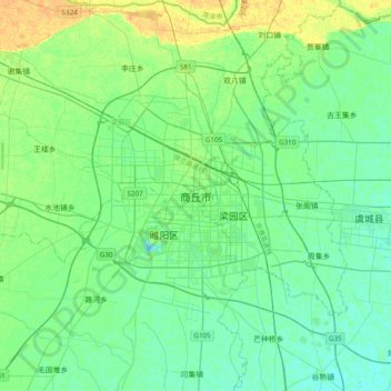
Nome: Mapa topográfico Shangqiu, altitude, relevo.
Local: Shangqiu, Liangyuan District, Shangqiu City, Henan, China (34.25710 115.49086 34.57710 115.81086)
Altitude média: 51 m
Altitude mínima: 44 m
Altitude máxima: 67 m
Shangqiu is the easternmost prefecture of Henan province. Its administrative area ranges in longitude from 114 °49′ E to 116° 39′ E and in latitude from 33° 43′ N to 34° 52′ N, covering 10,704 square kilometres (4,133 sq mi). The city lies on the North China Plain and is mostly flat, with elevations ranging from 30 to 70 metres (98 to 230 ft), though the northwest part of the prefecture is more elevated than the southeast.
Outros mapas topográficos
Clique em um mapa para visualizar sua topografia, sua altitude e seu relevo.
Suiyang District
Suiyang District, Shangqiu, Henan, China
Altitude média: 48 m