
Mapa topográfico Kalaburagi
Mapa interativo
Clique no mapa para exibir a altitude.
Sobre este mapa
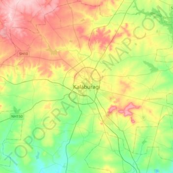
Nome: Mapa topográfico Kalaburagi, altitude, relevo.
Altitude média: 465 m
Altitude mínima: 385 m
Altitude máxima: 582 m
The entire district is on the Deccan Plateau, and the elevation ranges from 300 to 750 m above MSL. Two main rivers, the Krishna and Bhima, flow through the district. The predominant soil type is black soil. The district has many tanks, which irrigate the land along with the river. The Upper Krishna Project is a major irrigation venture in the district of Kalaburagi. The main crops are groundnuts, rice, and pulses. Kalaburagi is the largest producer of toor dal, or pigeon peas, in Karnataka. Kalaburagi is an industrially backward district but is showing signs of growth in the cement, textile, leather and chemical industries. Kalaburagi has a university with Medical and Engineering Colleges. Central University of Karnataka (CuK) is located in Kadaganchi, Åland Taluk of Kalaburagi. The geographical area of the city is 64 square kilometres.
Outros mapas topográficos
Clique em um mapa para visualizar sua topografia, sua altitude e seu relevo.
Melakunda
India > Karnataka > Kalaburagi taluku
Melakunda, Kalaburagi taluku, Kalaburagi District, Karnataka, India
Altitude média: 440 m
Kalaganura
India > Karnataka > Kalaburagi taluku
Kalaganura, Kalaburagi taluku, Kalaburagi District, Karnataka, 585106, India
Altitude média: 495 m